Revised in 2019, this is a must-have map for Adirondack outdoor enthusiasts. Waterproof large-format map provides excellent detail for trips by car or by foot. Includes trail information from ADK’s guidebook, High Peaks Trails.
All of the major public hiking trails are shown on the maps, including mileages, heights, summits, lean-to and campsite locations, appropriate trail uses, parking areas, boat launches, and much more. Approximate scale 1:75,000. Contour interval = 50 feet.
Produced by National Geographic and ADK.
ADK Members receive a 10% discount.
Save if you purchase the map packaged with the guidebook in the High Peaks Trails and Map Pack.
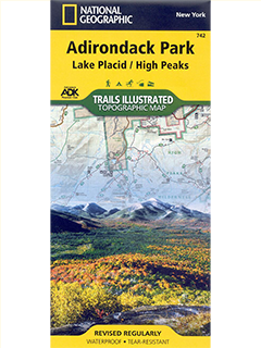
Lake Placid/High Peaks Map #742
$14.95
Trails Illustrated Topographic map of Lake Placid/High Peaks #742
In stock